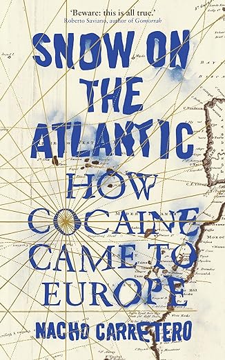
Do you recognize the country of the following map? It’s a map of the Kingdom of Galicia. And as far as we know it’s the first printed map of Galicia.

The map is drawn by Hernando Ojea and appears in the book Theatrum Orbis Terrarum (Theater of the world) by Abraham Ortelius in 1603
Very impressive how they were able to make maps in those days. Without all the modern technologies of today. Off course, the map is not entirely correct. Therefore it’s called Descripción del Reyno de Galizia (Description of the Kingdom of Galicia). Still you recognize Galicia instantly! (at least I did :D)
What is shown on this map?
What is notable on the map is the use of two different languages. Names of places are written in Spanish (Orense, Tierra de Ulba). While the title, legend and waters are in Latin. For example ‘Gallaecia Regnum’ (Kingdom of Galicia) en ‘Oceanus Occidentalis’ (Western Ocean).
Many places we still know today are visible on the map. Such as Lugo and Ourense. Also clearly visible are the Rías Baixas.
And what is also clearly visible are some significant buildings, as the Torre de Hercules in A Coruña and the Cathedral of Santiago de Compostela.
What do you recognise on this first map of Galicia?


